‘The main object of a burial-ground is, the disposal of the remains of the dead in such a manner as that their decomposition, and return to the earth from which they sprung, shall not prove injurious to the living; either by affecting their health, or shocking their feelings, opinions, or prejudices.
A secondary object is, or ought to be, the improvement of the moral sentiments and general taste of all classes, and more especially of the great masses of society.’
John Claudius Loudon – On the Laying Out, Planting and Managing of Cemeteries; And on the Improvement of Churchyards (1843)
Throughout this website the terms burial ground or graveyard are used to denote the area around Wainsgate chapel used for burials and interment of ashes. The burial ground of a Nonconformist chapel is also sometimes referred to as a chapelyard (the Commonwealth War Graves Commission list Wainsgate’s burial ground as a chapelyard).
It is important to note that Wainsgate’s burial ground is not, and never has been, consecrated (‘a ritual and legal act, dedicating for holy use an object, building or place’), a term that does not generally apply to Nonconformist graveyards.
The burial ground is not strictly speaking a cemetery, which are almost always owned by private companies, local authorities or other public bodies:
‘Burial space generally including consecrated and unconsecrated sections, subject to civic legislation, and intended to serve the entire parish or community’.
Neither is it a churchyard:
‘Consecrated parish burial space, sometimes but not always surrounding a church, owned by the Church of England and subject to canon law’.
It has the legal status of a private burial ground, and as such is not subject to the legislation covering consecrated Church of England graveyards (common law and ecclesiastical Measures) nor to the legislation covering municipal cemeteries (Local Authorities’ Cemeteries Order 1977) .
(Definitions by Dr Julie Rugg, University of York, Cemetery Research Group)
* * *
Click on the LINKS to find out more…..
HISTORY & CONTEXT
PLANS of the BURIAL GROUND
Areas of the graveyard – Graveyard plans from 1849, 1875 and 1905 – CAD Plans.
The OLD GRAVEYARD
OLD YARD
FIRST BURIALS
The first recorded burial at Wainsgate was that of Martha Whitaker, on 7th April 1762.
FAWCETT YARD
COUSIN YARD
AREAS A & B
The NEW GRAVEYARD
The existing burial ground was becoming full by the end of the nineteenth century: adjoining land was purchased and the new burial ground opened in 1905.
PLOT NUMBERING
It’s complicated…..
RULES & REGULATIONS
John Cousin’s 1837 declaration – 1926 Graveyard Rules – Receipt Books – LACO legislation – ‘Lift & Deepen’.
The SUNDIAL
Erected in 1923, now only the base remains. What happened to it?
* * *
‘The world was made for the dead. Think of all the dead there are…
There’s a million times more dead than living and the dead are dead
a million times longer than the living are alive…’
From You Can’t Be Any Poorer Than Dead / The Violent Bear It Away by Flannery O’Connor (1960)
‘Sometimes I stand among the stones and wonder.
Sometimes I laugh, sometimes I weep.
Sometimes nothing at all much happens.
Life goes on. The dead are everywhere.’
From The Undertaking: Life Studies from the Dismal Trade by Thomas Lynch (1997)
HISTORY & CONTEXT
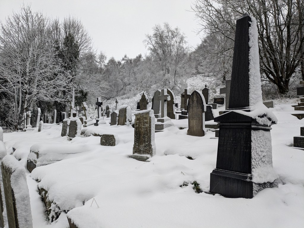
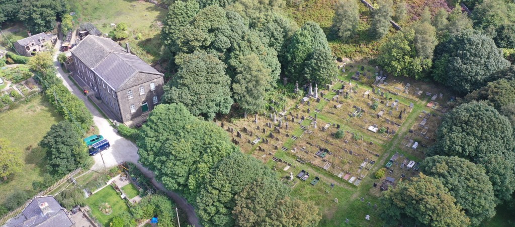
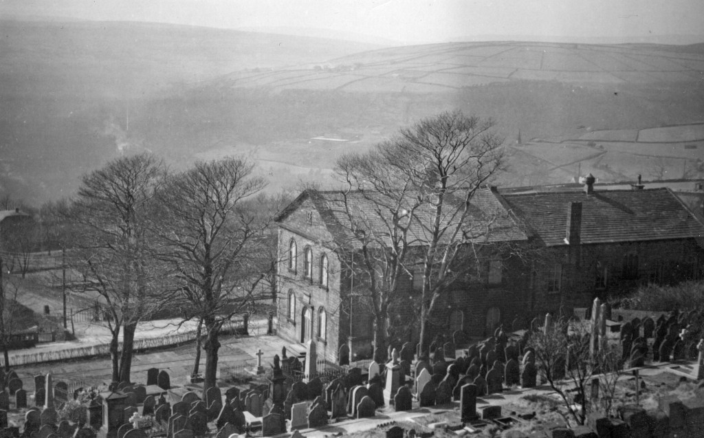
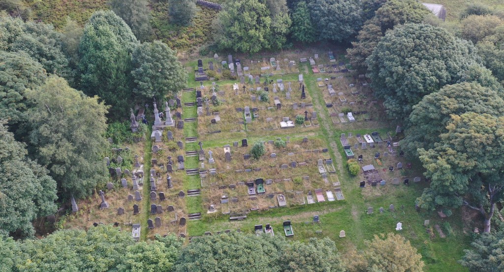
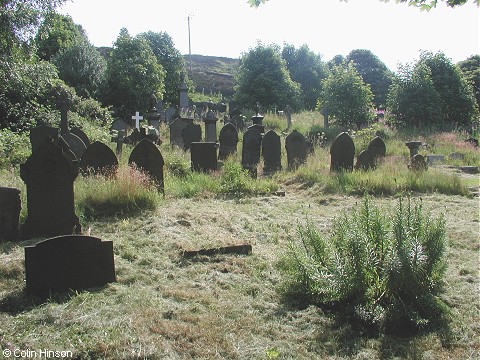
Wainsgate chapel is situated on the edge of open moorland on the hillside above Hebden Bridge, 290m above sea level. The burial ground lies to the east and south of the chapel, and slopes steeply downwards from east to west with open views across the Calder valley to the west. It covers a total area of about 0.66ha (1.6 acres), which includes a ‘wild’ area (not used for burials) of bilberries, heather and other vegetation along the eastern edge and a small grassed area in the south west corner. The western boundary with Wainsgate Lane consists of a low stone wall with metal railings, privet hedge and two pairs of iron gates: all the other boundaries are dry stone walls. There are around 30 mature trees in the burial ground, and a small stone building (the ‘gravediggers’ hut’) in the south west corner. The historic plans of the graveyard show around 1,557 grave plots identified and numbered (the various plans show different numbers of plots, so the total is not exact), and it is thought that around 1,350 of these have been used or purchased for future use. All of the plots lie on an east-west axis, with the head of the grave at the eastern end.
The first Baptist chapel at Wainsgate was built in 1750, was rebuilt in 1815 and 1860, and remodelled in 1891 to form the current chapel and attached Sunday school. The chapel closed for regular worship in 2001 and was transferred from the Yorkshire Baptist Association to the Historic Chapels Trust in 2005. The ownership of the chapel, Sunday school and burial ground passed to Wainsgate Chapel (Charitable Incorporated Organisation No.1198994) in March 2026.
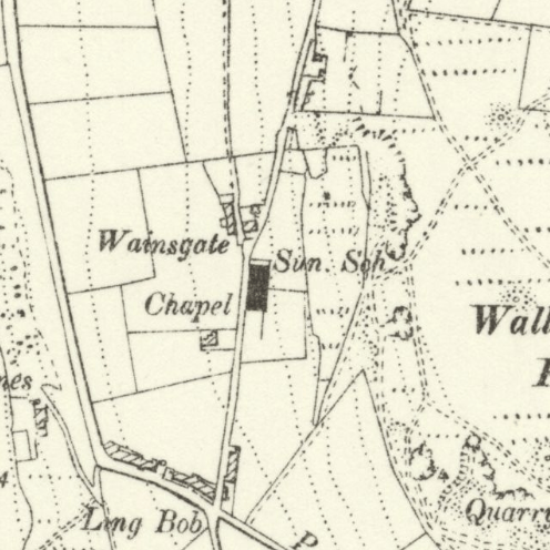
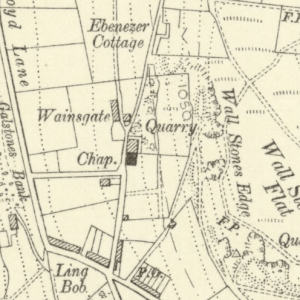
Top left: from Halifax Guardian Almanac, 1905. Top right: Wainsgate c1849.
Bottom left: Wainsgate c1892. Bottom right: Wainsgate c1905.
Map extracts (not to scale) from OS 6″ to 1 mile maps. Reproduced with the permission of the National Library of Scotland
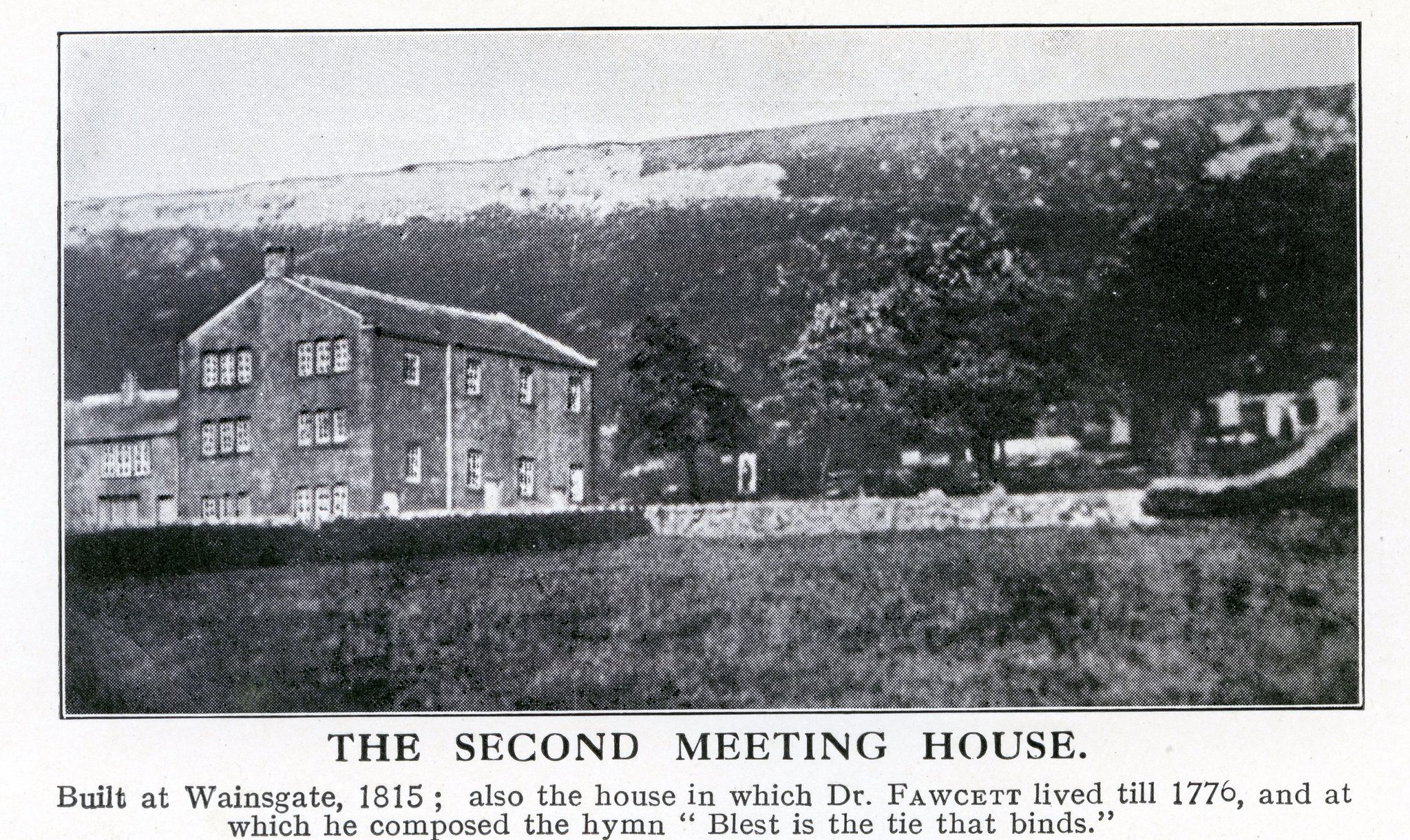
The 1849 map shows the position of the second Meeting House, built in 1815 and demolished in 1860. Note the external Baptismal Cistern. The 1892 map shows the chapel and Sunday school as they are today, and also the new manse, Cousinville. The 1905 map shows the new graveyard and gravediggers’ hut and the track connecting Wainsgate Lane to Akroyd Lane.
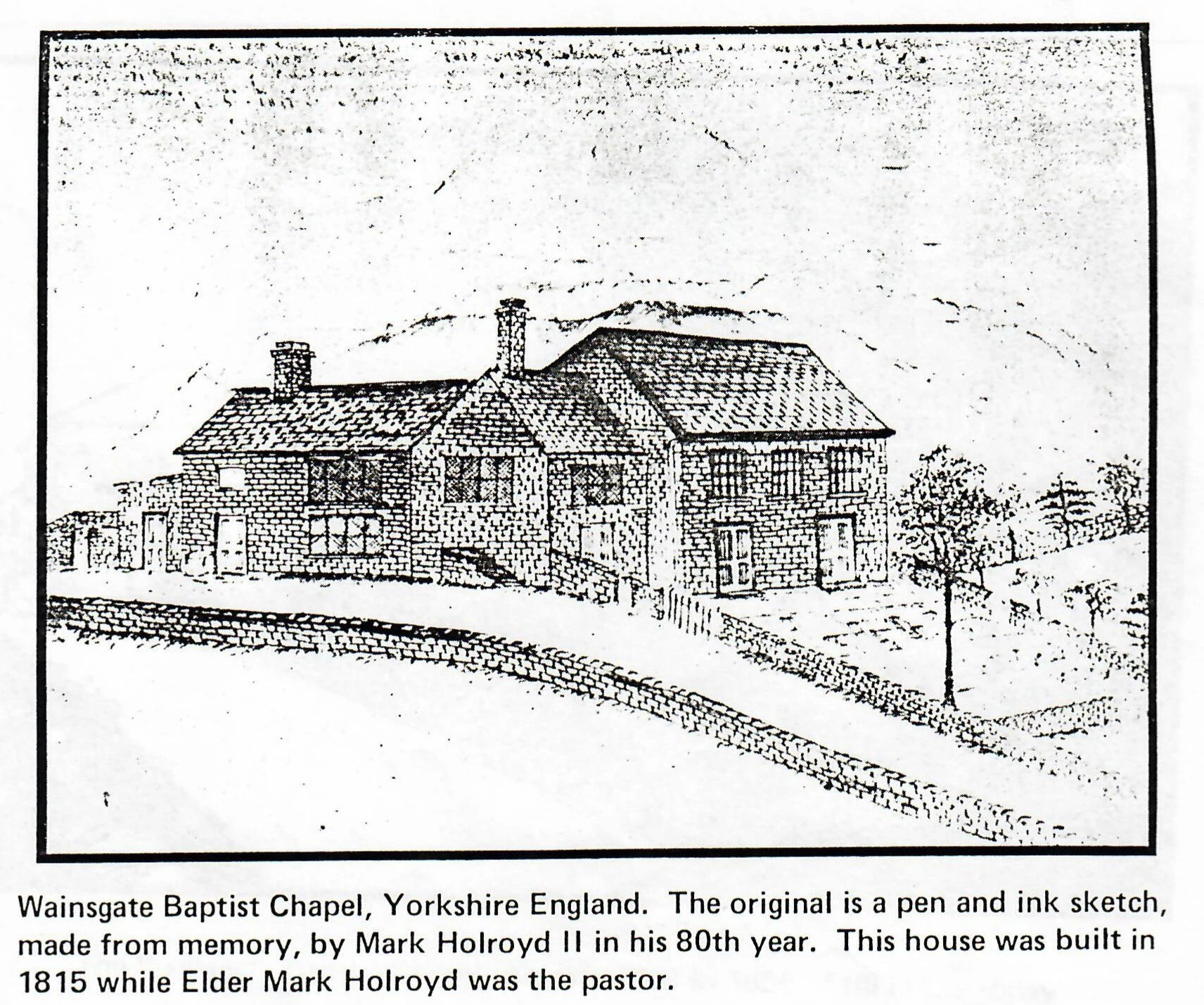
The pen and ink sketch above was made by Mark Holroyd II (1816-1902), son of Mark Holroyd (c1766-1854) who was minister at Wainsgate from 1810 to 1835, and who was responsible for building the second meeting house shown in the photograph and sketch. The sketch was made from memory in around 1895, 60 years after the family had emigrated to America, which probably explains why the building shown in the sketch is quite different from the photograph.
The sketch was made while Mark was staying with his daughter in Colorado, and shows the Rocky Mountains in the background – apparently they reminded him of the hills around Wainsgate.
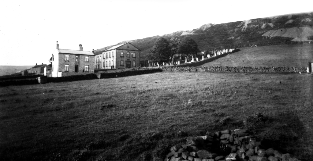
This photograph was probably taken around 1900 – after the building of the new manse, Cousinville in 1891, and before the creation of the new graveyard in 1905. Note the evidence of quarrying on the hillside above Wainsgate – known as ‘Wall Stones Edge’: the stone from these quarries was probably used to build the chapel, the Sunday school, the manse and many of the houses, farms, mills and other buildings in Old Town.

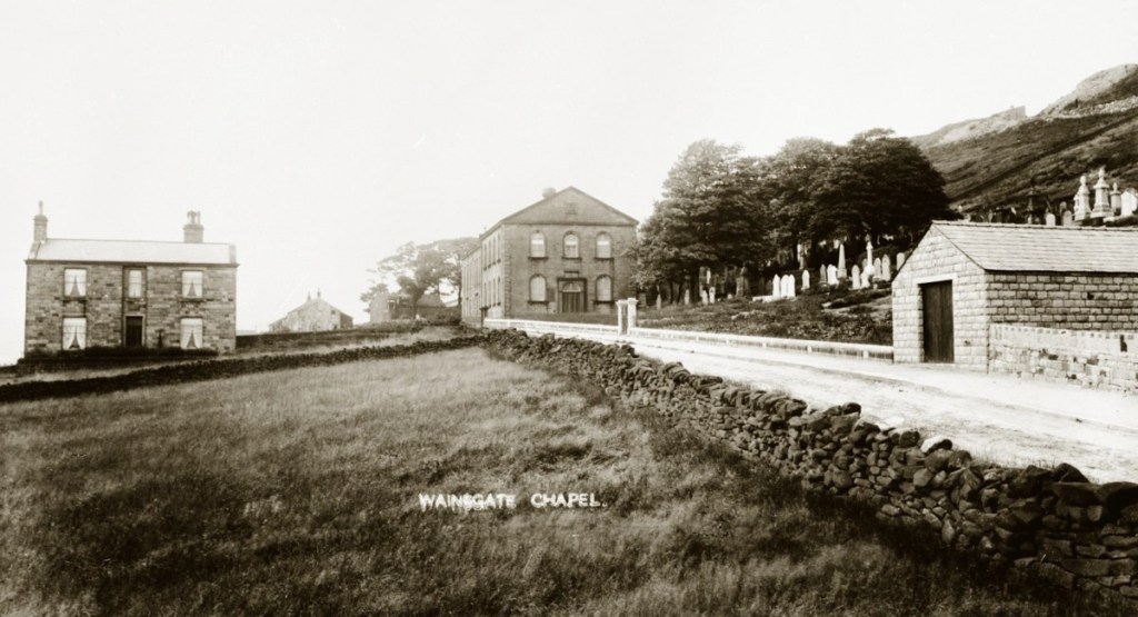
These photographs were taken shortly after the new graveyard was created in 1905 – the new boundary wall, railings, gate and gravediggers’ hut look to be newly built.
* * *
The first recorded burial at Wainsgate was on 7th April 1762, and since then over 3,000 people have been interred there. The graveyard is still in use as a private burial ground, open to people of all religious and non-religious traditions for full burials or interment of ashes: Please contact us if you would like more information.
PLANS of the BURIAL GROUND
AREAS OF THE GRAVEYARD
The graveyard can be divided into two distinct areas: the ‘old graveyard’ and the ‘new graveyard’.
The old graveyard can be further sub-divided into five distinct areas, known as: ‘Old Yard’, ‘Cousin Yard’, ‘Fawcett Yard’, Area A & Area B.
The new graveyard, which came into use in 1906 is sub-divided into Areas C – K. The naming of Areas A – K was instituted by the Historic Chapels Trust, and has been maintained (although the areas designated A and B have been amended).

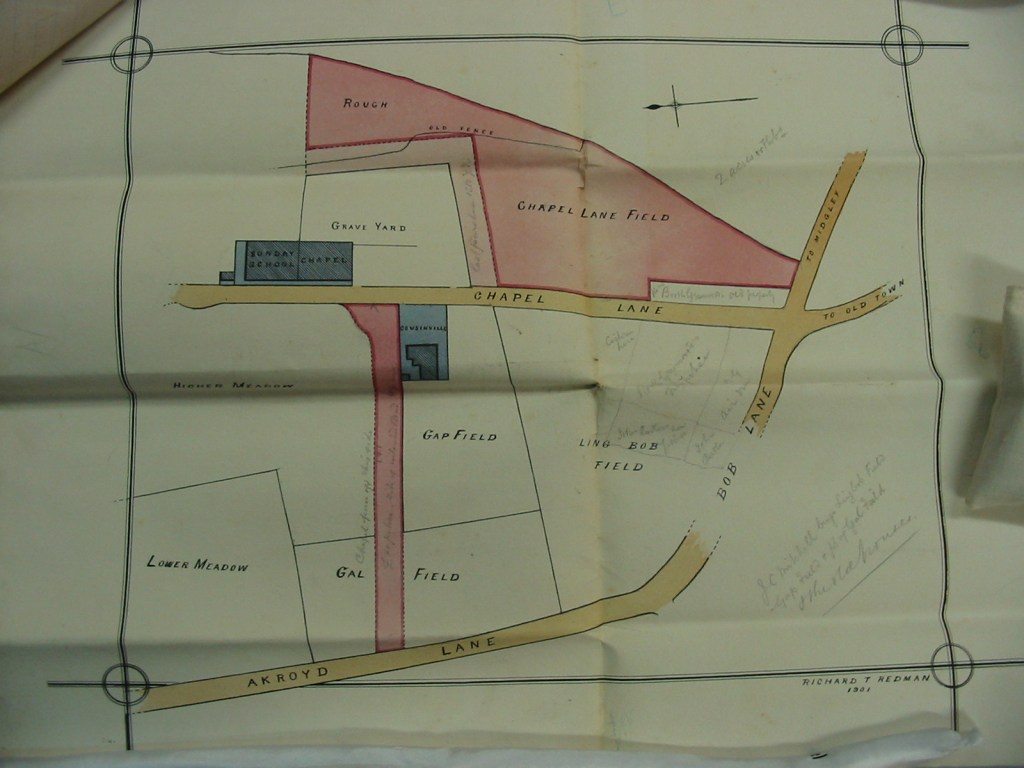
There are five known historic plans of the burial ground at Wainsgate: three believed to date from 1849, one dated June 1875, and an undated plan which is believed to have been made around 1905.
1849 PLANS
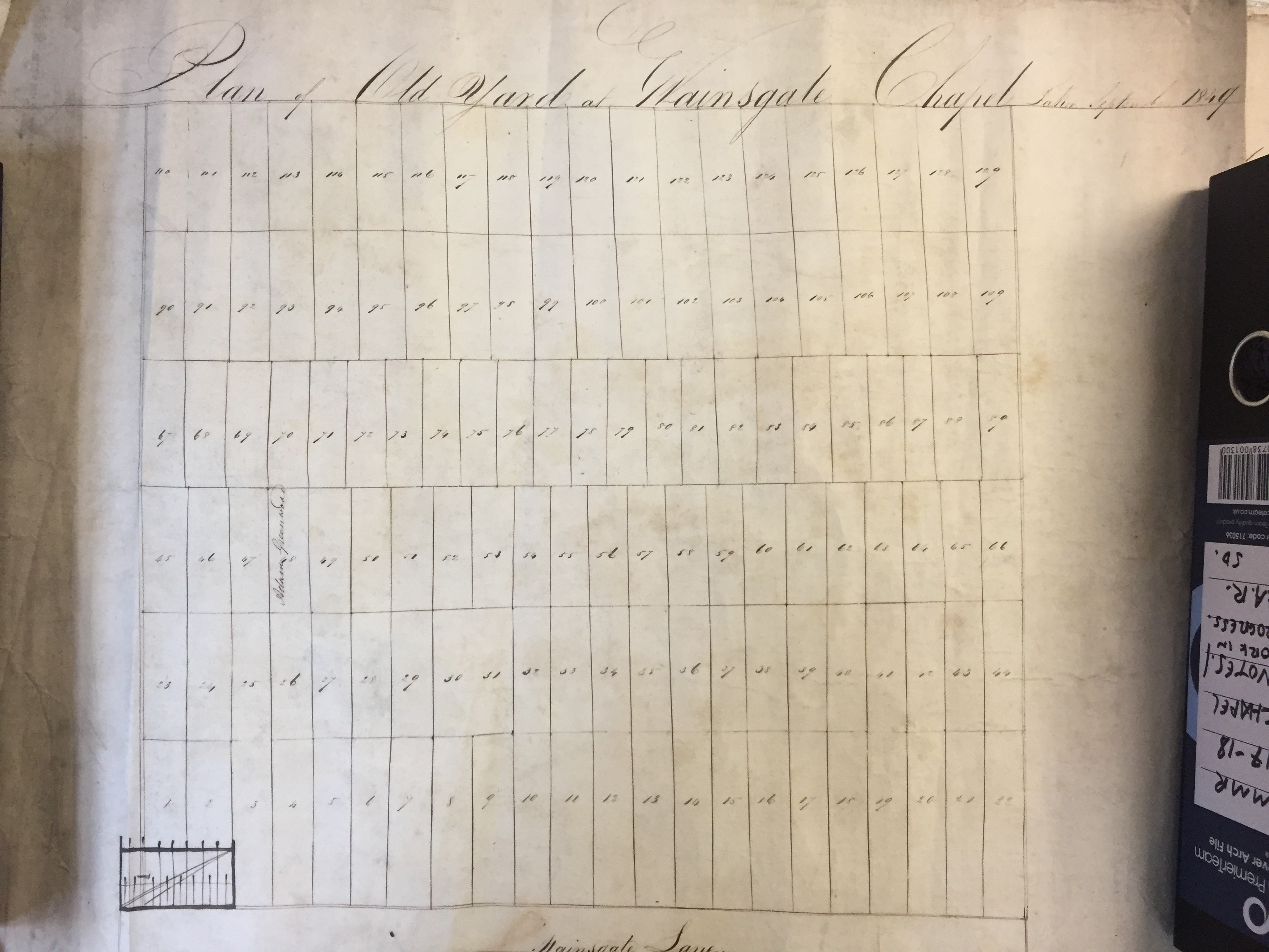
The three 1849 plans are very simple plans, not to scale, and showing only plot layout and numbering. They are titled ‘Old Yard’, ‘Mr Fawcett’s Yard’ and ‘Yard given by Mr Jno Cousin Senr’. Two of the plans are dated September 1849 – the third is undated but looks to have been drawn by the same person at the same time.


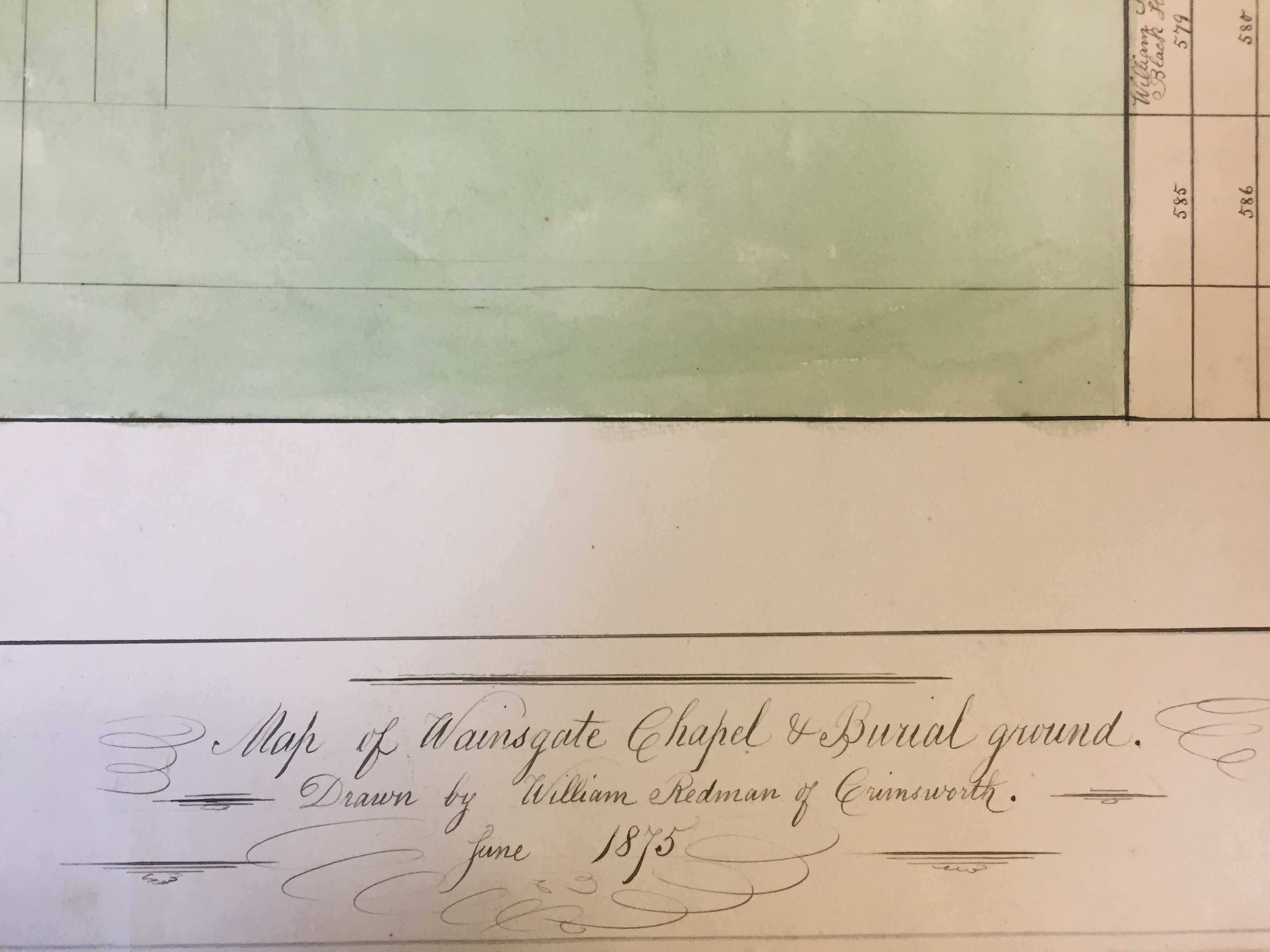
1875 PLAN
The 1875 plan is a large unframed plan, not to scale, and covering the whole of the old graveyard. It is titled ‘Map of Wainsgate Chapel & Burial ground’, drawn by William Redman of Crimsworth, June 1875. It shows plot layout and numbering for Areas A & B, and some plots show the name of the grave owner. No information is given for the ‘Old Yard’, and ‘Fawcett Yard’ and ‘Cousin Yard’ show only the location and name for a few plots, with no numbers.
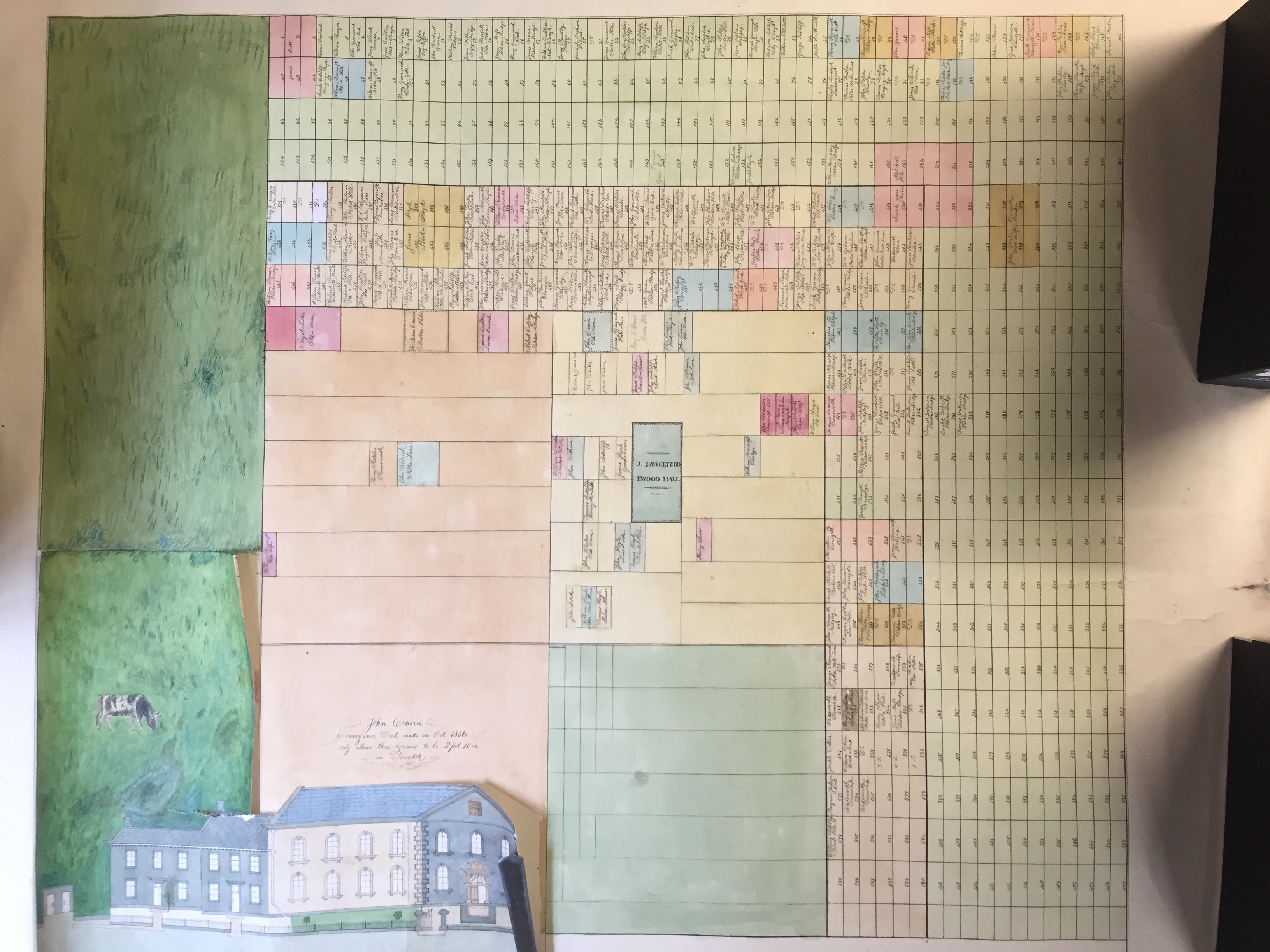
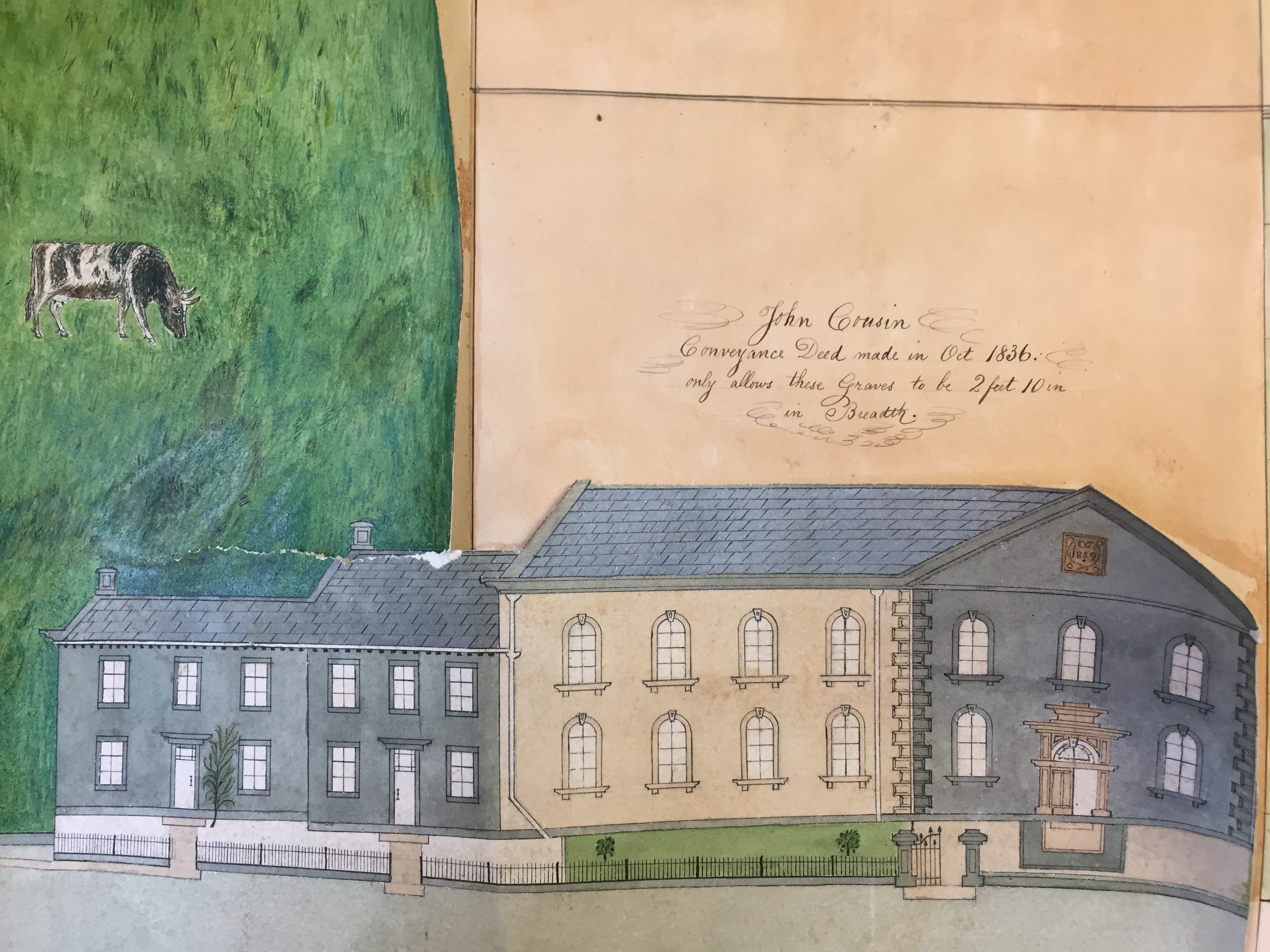
The plan also includes an elevational drawing of the chapel, showing the Sunday school and manse prior to the 1891 remodelling, as well as a cow grazing in the field next to the chapel. William Redman (1820–1890) was listed in the 1881 census as a farmer of 36 acres, which perhaps explains the cow, but was obviously also quite a capable draughtsman. His family have an impressive granite memorial in the old graveyard (plots B203a/204a/215a/216a).
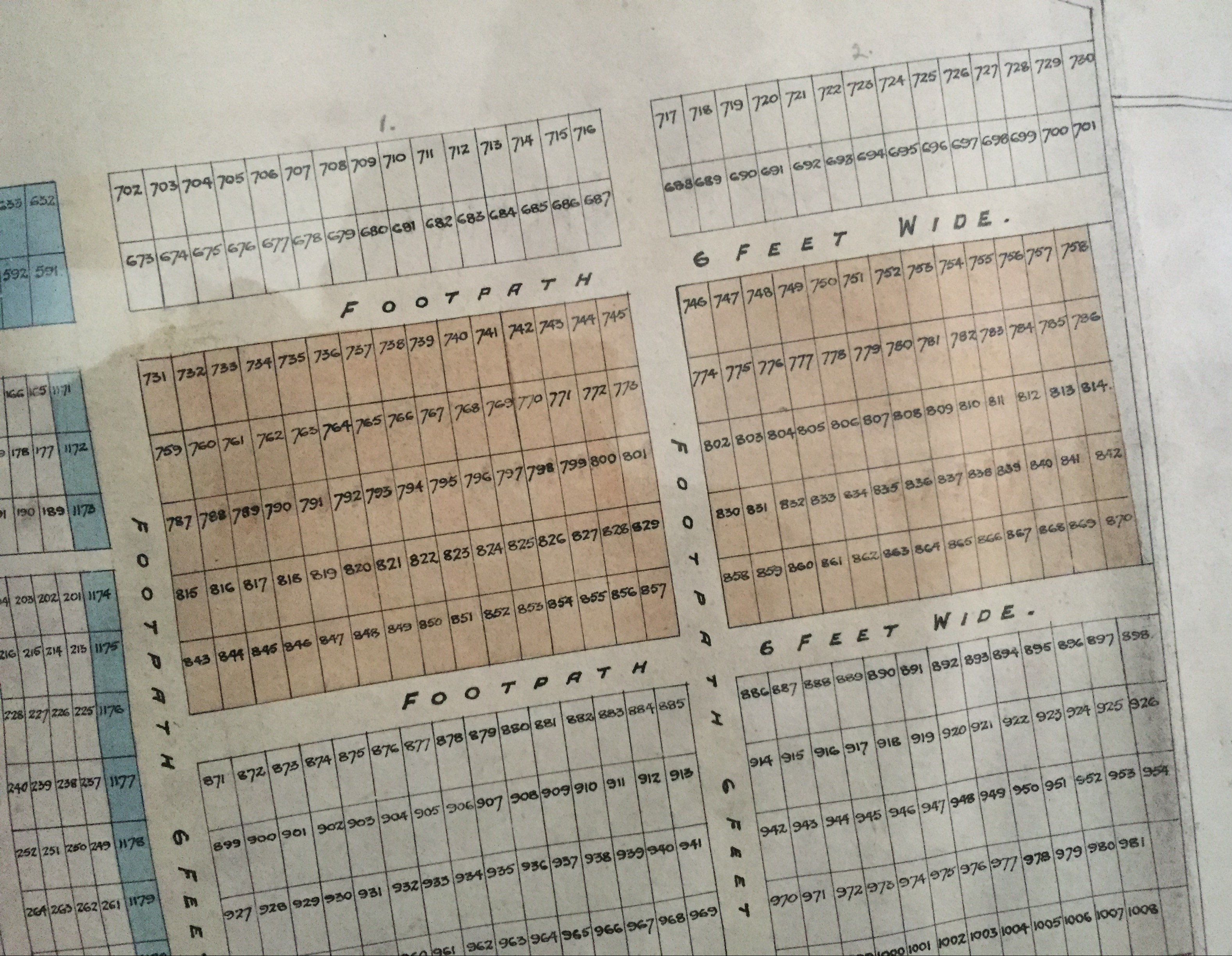
1905 PLAN

The large framed plan, ‘Plan of Baptist Church Grave Yard, Wainsgate’ shows the old and new graveyards, and is assumed to have been drawn when the new graveyard was completed in 1905. It was produced by John Judson & Hudson, Architects & Surveyors, of Oakworth and Bradford, and appears to be reasonably accurate. It shows the entire burial ground, including the uncultivated area to the east of the graveyards, the chapel, Sunday school and other buildings, and part of Wainsgate Lane. All of the plots are numbered, but no names of grave owners are included., and the plan does not show the locations or numbering of graves in the ‘Old Yard’. There is also a key showing the plots in the new graveyard categorised as Class A, B, C, D, E or F: different prices were charged for the various classes of burial plot.
(The 1849 and 1875 plans are kept in the Hebden Bridge Local History Society archive at the Birchcliffe Centre, and the 1905 framed plan is displayed in the Sunday school at Wainsgate).
CAD PLANS
The burial ground is in the process of being surveyed and the positions of graves, trees and other features plotted with AutoCAD software. Pdfs of all areas of the new graveyard, showing positions of grave plots and the names and dates of those interred or commemorated, can be downloaded here. Plotting of the old graveyard is ongoing, and plans will hopefully be available soon.
The OLD GRAVEYARD
The first meeting house at Wainsgate was built in 1750 and was rebuilt in 1815 and 1860. The current building occupies the same footprint as the 1860 chapel, but there are no records of the exact size and location of the earlier buildings.
The earliest known burials in the three areas of the old graveyard adjacent to the chapel all predate the rebuilding of the chapel and Sunday school in 1860: the dates of the earliest burials are thought to be 1762 in the Old Yard, 1815 in Fawcett Yard and 1830 in Cousin Yard.
The original graveyard was purchased in 1762 (which was the year when the first burials at Wainsgate were recorded), and it is assumed that this was the ‘Old Yard’. It is uncertain whether this graveyard was affected by the rebuilding of the chapel in 1815 and again in 1860 and whether the gravestones in this area are in their original positions, although we do know that some gravestones were moved when the path from the chapel entrance to the bottom of the stepped path was made around 1950 (Graveyard Committee Minute Book 1945-1965, R / WAI 13S).
OLD YARD
‘Old Yard’ is situated immediately to the south of the chapel, adjacent to Wainsgate Lane, and covers an area of about 220m2. The 1849 plan shows 129 numbered plots, but gives no detail regarding its exact location and boundaries, apart from showing Wainsgate Lane and the entrance gate. Only one plot has the name of the grave owner included. No details of the layout or numbering of the Old Yard are shown on the plans of 1875 and 1905.
The FIRST BURIALS
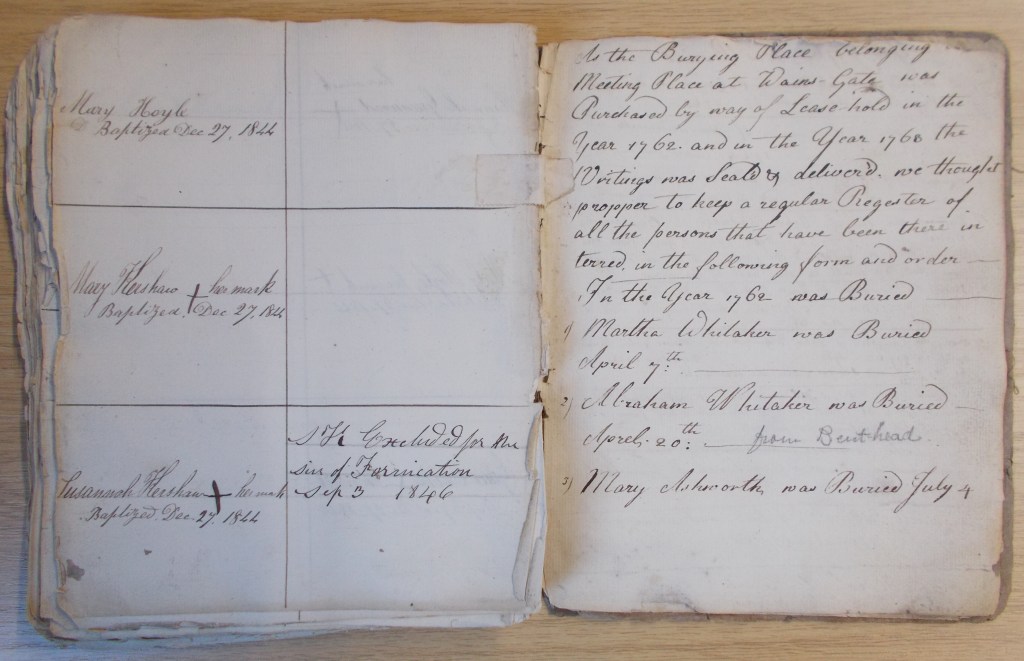
As the Burying Place belonging (……?) Meeting Place at Wains-Gate was Purchased by way of Lease-hold in the Year 1762, and in the Year 1763 the Writings was Seal’d & deliver’d, we thought propper to keep a regular Regester of all the persons that have been there interred, in the following form and order –
A register of members in the WYAS archive at Halifax (WYC: 1897/2) contains details of some of the earliest burials at Wainsgate, the first recorded burial being Martha Whitaker on 7th April 1762. The next nine recorded burials date from 4th July 1762 to 21st June 1765, one of them being Richard Smith, first minister at Wainsgate, who died in 1763 and seems to be the fourth person buried at Wainsgate. There are then two more numbered entries, both for Emanuell Redman, although one of the entries has been partly crossed out: the date is probably 1778, but could possibly be 1787.
There are then six unnumbered entries for burials in 1787, two for burials in 1801 and entries for the burials of Grace Whitaker in 1838 and her husband Simon Whitaker in 1838: both of these burials are also recorded in the main burial register.

A transcription of these entries can be viewed here.
To date only three of the graves for these burials have been identified:
Richard Smith (first pastor at Wainsgate) is buried in plot OY125.
Grace Whitaker and Simon Whitaker are buried in plot OY99. Grace died on 24th January 1833 aged 74, and her husband Simon died on 17th September 1838 aged 80.


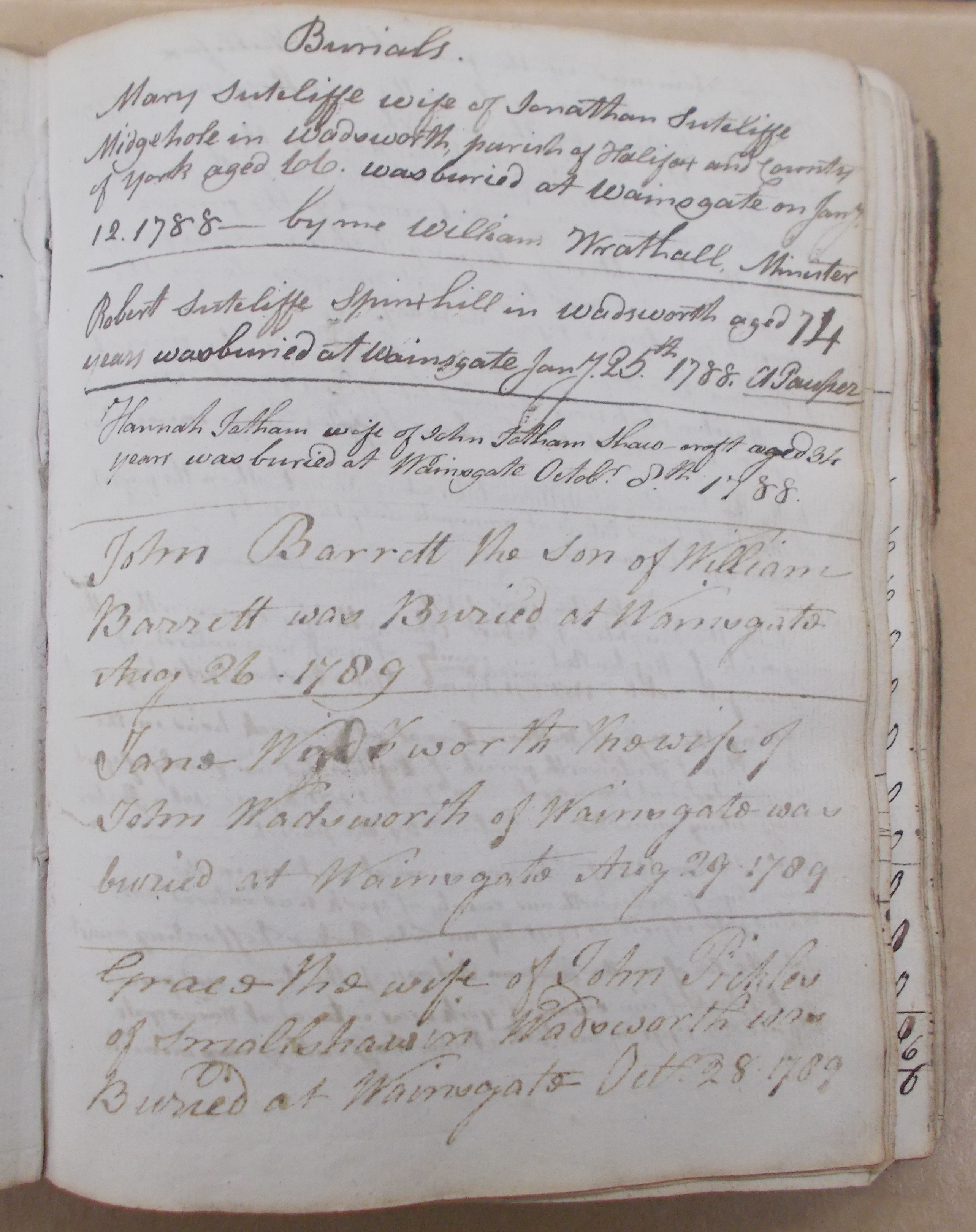
An account book in the Birchcliffe Archive (R / WAI 5S) contains a list of 30 burials from 1788 to 1800: three ministers are named as having conducted the burials – William Wrathall (minister from 1788-1790), John Parker (1790-1792) and Isaac Normington (1800-1810).

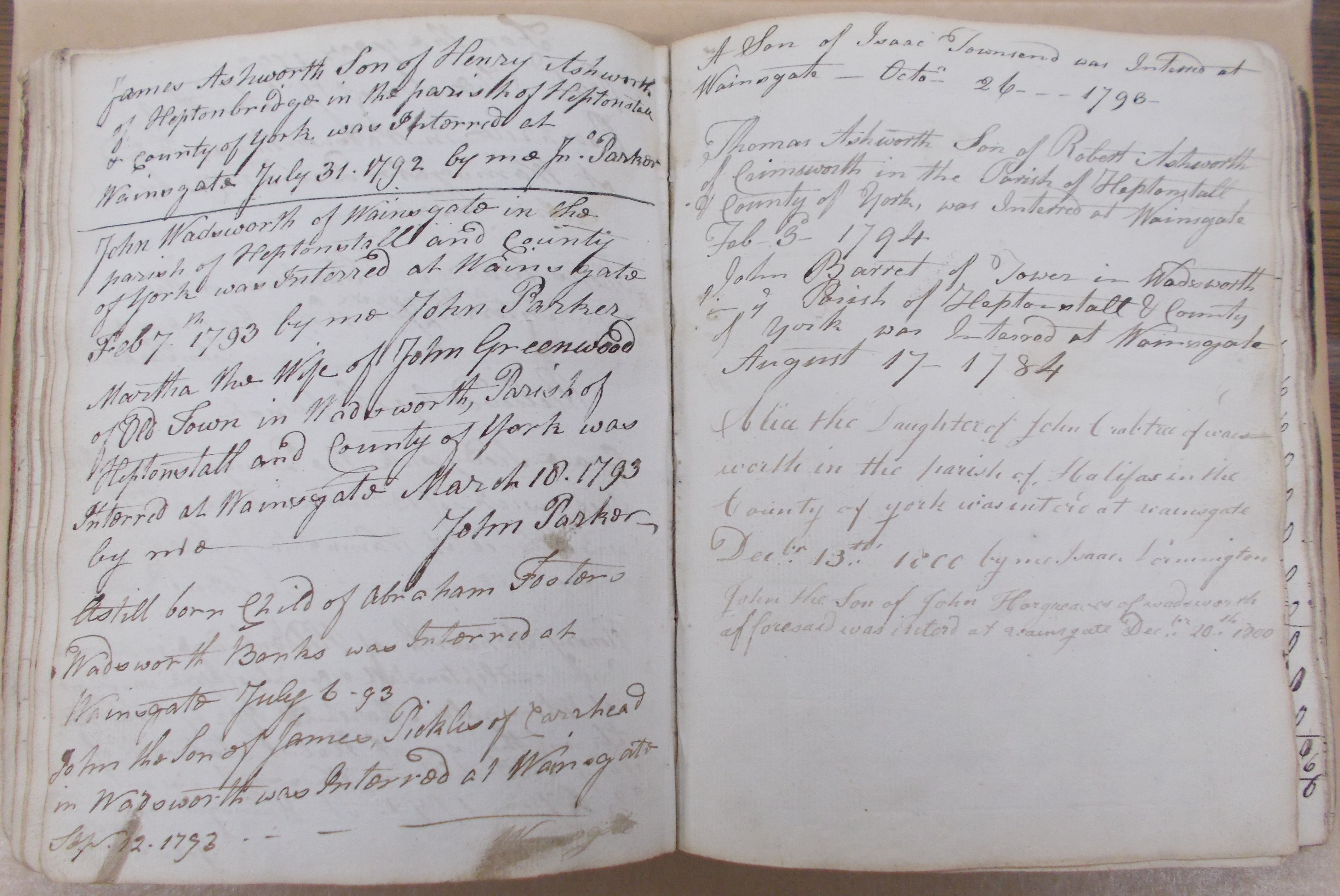
Pages of account book (R / WAI 5S) showing records of early burials at Wainsgate.
A transcription of these entries can be viewed here.
FAWCETT YARD
‘Mr Fawcett’s Yard’ (or ‘Fawcett Yard‘) is situated immediately to the southeast of the chapel, and covers an area of about 270m2. The 1849 plan shows 135 numbered plots, and five plots have the name of the grave owner included. The 1875 plan gives an indication of the location and layout, with a few names of grave owners but no plot numbers. Rev. John Fawcett’s tomb is prominent in the centre of the plan, marked ‘J.FAWCETT DD, EWOOD HALL’. The 1905 plan shows plot numbers, but no names, and 18 plots have been omitted, giving a total of 117 plots.
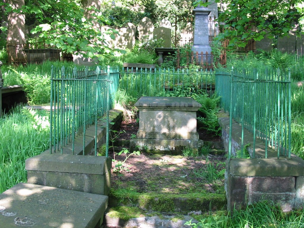
‘Mr Fawcett’ is Rev. John Fawcett (1739–1817), minister at Wainsgate from 1763 to 1777, whose family tomb (FY188-206) is at the centre of Fawcett’s Yard. Six members of his family are interred with him: his wife Susannah, his son John Fawcett jnr and his wife Ann, and three grandchildren, Esther, John Hargreaves Fawcett and Eliza Ann.
John Fawcett built a home in Hebden Bridge for his retirement, which he called Machpelah. In 1810 his wife Susannah Fawcett (born Skirrow) died aged 74, and was buried in a vault at Machpelah, as was his grandaughter Esther (daughter of John Fawcett jnr and his wife Ann), who died in 1811 aged 9. Rev. Fawcett bought ‘Mr Fawcett’s Yard’ at Wainsgate with the intention that he was to be buried there and that the remains of his wife and grandaughter were to be disinterred and buried with him.
Machpelah, also known as the Cave of the Patriarchs, Tomb of the Patriarchs, and to Muslims as the Ibrahimi Mosque is a series of caves situated 30 kilometres south of Jerusalem in the heart of the Old City of Hebron in the West Bank. According to the Book of Genesis, Abraham purchased the land for use as a burial plot from Ephron the Hittite, and describes how the three patriarchs (Abraham, Isaac and Jacob) and their wives, the matriarchs (Sarah, Rebekah and Leah), were buried there. Jewish midrashic literature claims that, in addition to the patriarch couples, Adam and Eve were also interred at Machpelah.
On October 10th 1816, less than a year before Rev. Fawcett died, his grandson John Hargreaves Fawcett died aged 20, and the burial register has an entry for 16th October which says only ‘Buried in Fawcett’s vault’. Presumably this was the burial of John Hargreaves Fawcett, but possibly this was also when Susannah and Esther were reinterred at Wainsgate. ‘John Fawcett D.D. Ewood Hall’ died on 25th July 1817 aged 77, and was buried in his vault on 29th July. The inscription on the tomb records another grandaughter, Eliza Ann Fawcett, who died in 1819 aged 3 weeks, but she is not recorded in the burial register. The other two burials in the vault, both recorded on the tomb and in the burial register are John Fawcett jnr of Ewood Hall, who died in 1837 aged 69, and his wife Ann Fawcett (born Hargreaves) who died in 1850 aged 76.
John and Susannah Fawcett had four children, three of whom predeceased their father:
Stephen Fawcett died of smallpox in 1774 aged 4. He is buried in the Old Yard (OY124), and the inscription on his gravestone reads ‘Ante adventum iptius mali tolitur‘ (He was taken from the evil to come).
Sarah Fawcett died in 1785, aged 18, and was buried at Ebenezer Chapel in Hebden Bridge – according to the inscription on her gravestone she ‘…supported a lingering indisposition with Christian patience and, in cheerful prospect of Immortality departed this Life, April 1, 1785’.
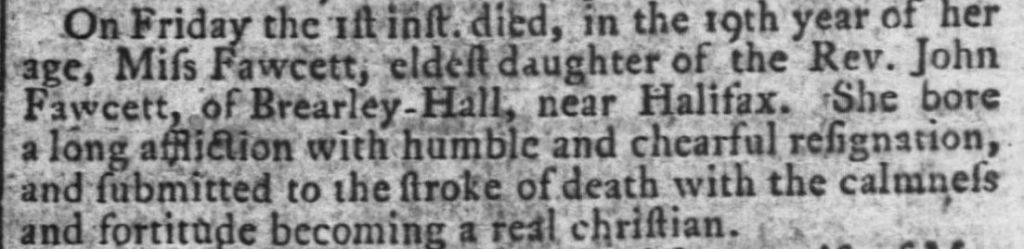
Leeds Intelligencer, April1785
His other daughter Jane married John Wright of Preston, with whom she had six children, and also predeceased her father, dying in Liverpool in 1811 at the age of 39.
John Fawcett jnr, who like his father became a ‘dissenting minister’, died in 1837 aged 69, and is interred with his father in the family tomb. He was the author of his father’s memoirs ‘An Account of the Life, Ministry and Writings of the Late Rev. John Fawcett D.D‘, published in 1818.
COUSIN YARD
The ‘Yard given by Mr Jno Cousin Senr’ (or ‘Cousin Yard‘) is situated immediately to the east of the chapel, and covers an area of about 250m2. The 1849 plan shows 114 numbered plots, none of which have the name of the grave owner included. The 1875 plan gives an indication of the location and layout, with a few names of plot owners but no plot numbers. The 1905 plan shows plot numbers, but no names, and also indicates two additional plots, bringing the number of plots to 116.
‘Mr Jno Cousin Senr’ is John Cousin, a cotton manufacturer, born in Oxenhope in 1770, who died in Old Town in 1838 and is described in the burial register as ‘Old John Cousin’. His grave (plots FY250/251) is at the top of Fawcett’s Yard, and is marked by a chest tomb surrounded by iron railings.
His son, John Cousin Jnr (1803–1837) of Ibbotroyd, who died shortly before his father at the age of 33, is buried in plot FY255, also in Fawcett’s Yard. The Cousin family is linked to several important local families: John Cousin Snr’s daughter Ann married Rev. Fawcett’s grandson Stephen in 1831, and John Cousin Jnr’s daughter Sarah Ann married Henry Mitchell in 1846.
At a meeting of 28th December 1837, John Cousin made a declaration:
‘I give you to understand that I have given this ground for the use of those who take the moral law for the rule of their conduct, and you must tell this when I am dead and rotten in my grave.’
AREAS A & B
Area A of the old graveyard is indicated on the 1875 plan as a distinct area, although not named as such. It is an ‘L’ shaped area immediately to the south and east of the Cousin and Fawcett yards, and its southern leg is shown on this plan as extending to the Wainsgate Lane boundary. It covers an area of about 400m2, and the 1875 plan shows 212 plots, most of which have the name of the grave owner indicated. The 1905 plan shows plot numbers, but no names. It includes an additional plot and also omits 6 plots, giving a total of 207 potential plots for this area.
Area B comprises the remainder of the old graveyard, and is an ‘L’ shaped area adjoining Area A. It covers an area of about 900m2, and the 1875 plan shows 416 plots, some of which (mostly those on the eastern edge) have the name of the grave owner indicated. The 1905 plan shows plot numbers, but no names. It includes two additional plots and also omits 12 plots, giving a total of 406 plots for this area. This plan also shows two paths running through Area B: one running north-south for the full length, and one running east-west and meeting it near its southern end. The latter path occupies an area previously allocated for grave plots, further reducing the number of potential plots to 389.
There are also 19 plots (Nos. 1171 – 1189) which strictly speaking belong in the new graveyard (they were created around 1905), but which are included in Area B since some of them are joined with plots in this area.

The NEW GRAVEYARD
The new graveyard (Areas C – K) lies to the south and east of the old graveyard, and the 1905 plan shows it covering an area of about 2,300 m2, which includes the wide paths running north-south and east-west. The 1905 plan shows 599 numbered plots, although 19 of these have been included in Area B of the old graveyard (see above). This total also includes a number of grave plots (around 80) which have not been used or purchased, and which are likely to be kept unused to preserve an area of open space at the bottom of the new graveyard. There are also a number of plots which are unlikely to be used for full burials due to proximity to trees or excessively rocky ground.
More coming soon……
PLOT NUMBERING
The numbering system for the grave plots is based on the 1905 framed plan, although this does not show the numbers or location of graves in the ‘Old Yard’ – these are based on the 1849 plans.
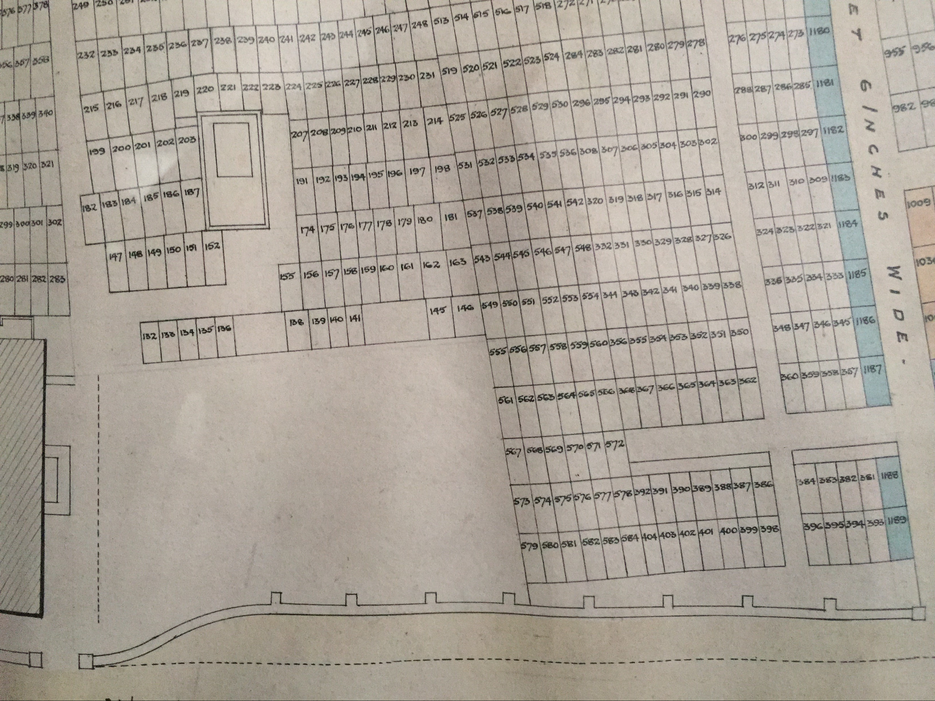
‘Old Yard’: The 1849 plan shows 129 plots, numbered 1 – 129. These numbers are prefixed with OY in the transcriptions and index.
‘Fawcett Yard’: The 1849 plan shows 135 plots, numbered 130 – 264. The 1905 plan omits 18 of these (130, 131, 137, 142, 143, 144, 153, 154 and 164 – 173), leaving a total of 117 plots (including the six plots that are allocated to Fawcett’s tomb). These numbers are prefixed with FY in the transcriptions and index.
‘Cousin Yard’: The 1849 plan shows 114 plots, numbered 265 – 378. The 1905 plan indicates two additional plots, numbered 266½ and 285½, bringing the number of plots to 116. These numbers are prefixed with CY in the transcriptions and index.
Area A: The 1875 plan shows 212 plots, numbered 379 – 590. The 1905 plan includes an additional plot, numbered 470½, and also omits plots 585 – 590, giving a total of 207 plots for this area. These numbers are prefixed with A in the transcriptions and index.
Area B: The 1875 plan shows 416 plots, numbered 1a – 416a. The 1905 plan includes two additional plots, numbered 128½a and 151½a, and also omits plots 405a – 416a. In addition, there are 17 plots shown on the 1875 plan (205a, 217a, 229a, 241a, 253a, 265a, 277a, 289a, 301a, 313a, 325a, 337a, 349a, 361a, 373a, 385a & 397a) which form a pathway and are omitted from the 1905 plan, leaving a total of 389 plots. These numbers are prefixed with B in the transcriptions and index.
Plots 1171 – 1189 should strictly speaking be included with the new graveyard, but are included in Area B since some of them are joined with plots in this area. These numbers are prefixed with B in the transcriptions and index.
The new graveyard: The 1905 plan shows 580 plots, numbered 591 – 1170. These numbers are prefixed with C, D, E, F, G, H, I, J or K in the transcriptions and index.
RULES & REGULATIONS
‘The most important rules respecting a place of burial must necessarily be those which have reference to the sacredness of the place, the security from disturbance of the bodies of the dead, the healthfulness of the living, and their improvement in sentiment and in morals.’
‘We would at all times keep every part of the cemetery in the highest order. The grass should be kept short and smooth by frequent mowing; the gravel free from weeds and smooth by frequent weeding and rolling; the edges, which we would form of concealed bricks or tiles, low, and constantly clipped; and the leaves, as they drop from the trees, should be picked up the same day on which they fell; litter of every kind picked up the moment it appeared; and the walls, chapel, lodge, gates, drains, &c., kept in constant repair.’
‘No dogs or improper persons; no smoking, drinking or even eating; no running or jumping, laughing, whistling or singing, or other practice that might indicate a want of reverence for the place, should be permitted. No person should be allowed to walk on the graves, or to cross from one walk or green path to another in places where the ground was filled with graves.’
John Claudius Loudon – On the Laying Out, Planting and Managing of Cemeteries; And on the Improvement of Churchyards (1843)
* * *
The earlist known ‘regulation’ concerning the burial ground at Wainsgate is found in a document in the Birchcliffe archive (R WAI / 6S), which contains the following declaration made by John Cousin, who donated the land for the area known as ‘Cousin Yard’:
At a meeting of 28th December 1837, John Cousin made a declaration:
‘I give you to understand that I have given this ground for the use of those who take the moral law for the rule of their conduct, and you must tell this when I am dead and rotten in my grave.’
An early burial register, started in 1849 (R WAI / 33S) contains the following rules, again applicable to ‘Cousin Yard’:
Rules respecting the ground bought by Jno Cousin Snr:
That every person on purchasing one grave or more, but not above three to pay 2/- for each grave, there being no extra charge till each grave be reopened. The deed also expressly states that no grave shall be dug less than 6 feet deep and not more than 2 feet 10 inches wide.
The Wainsgate Chapel Minute Book 1915-1934 (R / WAI 10M) contains a ‘Report of the sub-committee appointed to draw up a set of rules for the Graveyard’. The report is dated 27th February 1926, and includes the names of the members of the Graveyard Committee – Edward Sutcliffe, Arthur Vince Greenwood, John Edward Greenwood and J. W. Parker (presumably organist John William Parker) and two ex-officio members, Mr R. Ashworth (presumably Raymond Ashworth, later to be choirmaster), the Graveyard Treasurer and Mr E. W. Haigh, the Secretary to the Trustees.
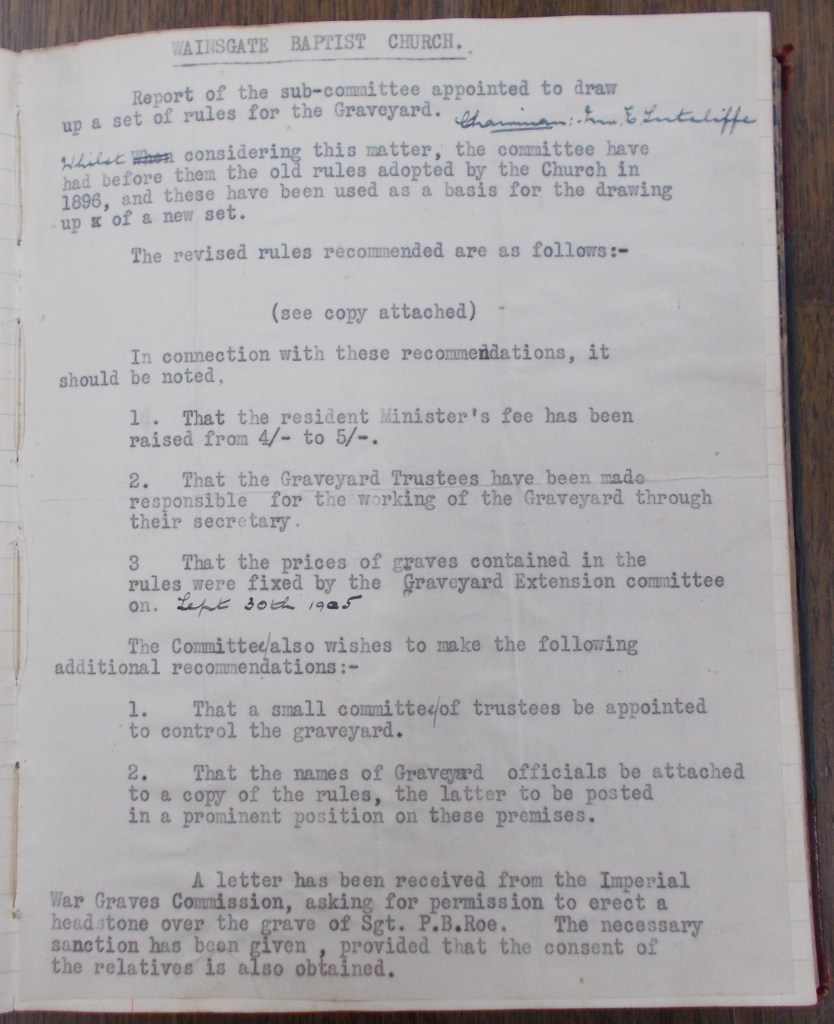
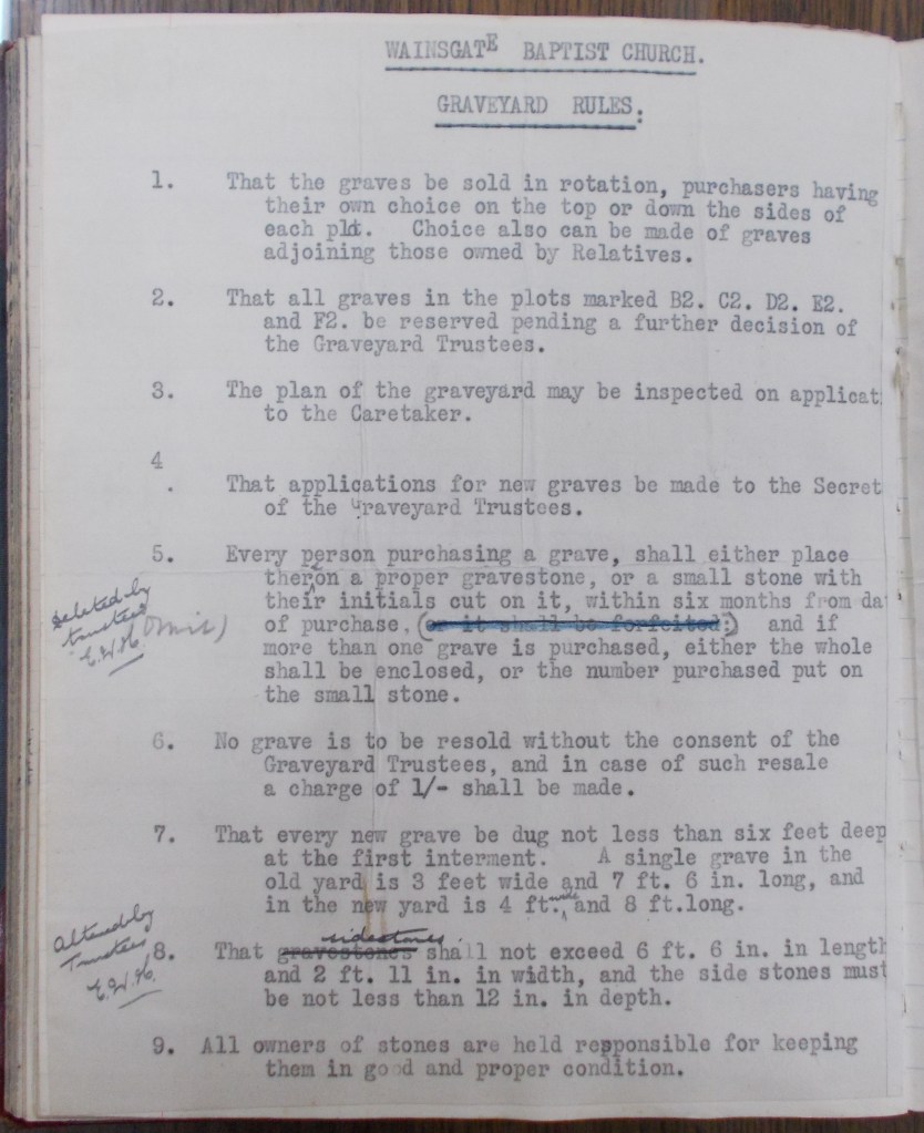
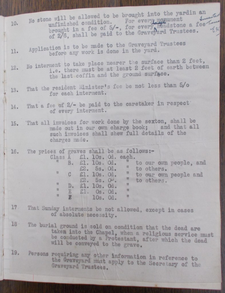
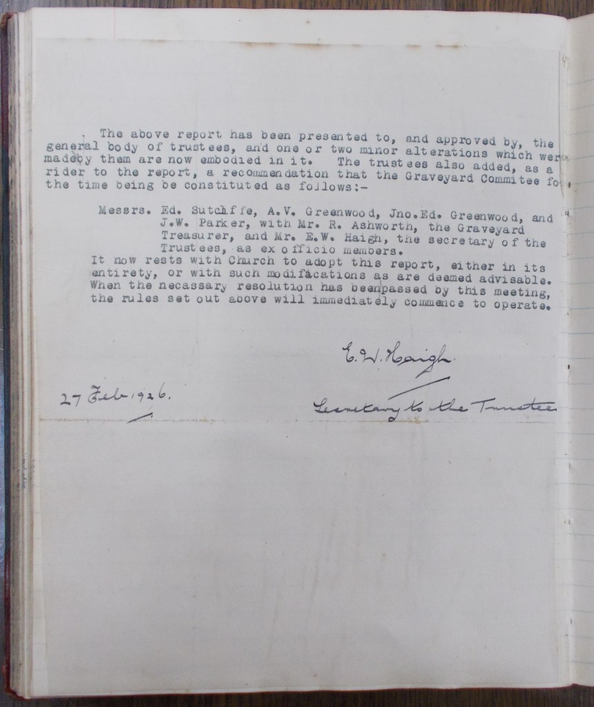
Rule 16 gives prices for the six different classes of grave plots (Classes A, B, C, D, E & F, which are marked on the 1905 Graveyard Plan), the prices ranging from 10s. 0d. to £2. 5s. 0d. It also sets out different prices for Class B and C graves for ‘our own people’ (presumably members of the Baptist church who worshipped at Wainsgate) and ‘others‘.
Rule 18 states:
‘The burial ground is sold on condition that the dead are taken into the Chapel, when a religious service must be conducted by a Protestant, after which the dead will be conveyed to the grave’.
The Receipt Books for the sale of burial plots (used from around 1870 until 2001) have the following printed on every receipt:
‘NOTE. – This Grave is Sold subject to the Rules of the Church concerning the Grave Yard. This Receipt to be shown to the Sexton previous to Grave being opened at each Interment. A Headstone with Initials or Name in full to be placed over Grave within twelve months or the Grave will be forfeited.’
* * *
Wainsgate is a private burial ground, and as such is not subject to the legislation covering consecrated Church of England graveyards (common law and ecclesiastical Measures) nor to the legislation covering municipal cemeteries (Local Authorities’ Cemeteries Order 1977) .
The LACO legislation requires that no part of a coffin should be less than 3 feet (900mm) below adjacent ground level, and that there should be a layer of earth of at least 6 inches (150mm) separating a coffin from a previously interred coffin. Assuming an average coffin depth of 15 inches (375mm), this means that a grave for a single burial should be at least 4 feet 3 inches (1275mm) deep, and a grave for a double depth burial should be at least 6 feet (1800mm) deep.
The LACO allows for the minimum cover to be reduced to 2 feet (600mm) where the soil is of a ‘suitable character‘, and this is generally accepted as a reasonable minimum cover in graveyards not covered by LACO regulations. A body buried in a shallow grave in a biodegradable coffin decomposes far quicker than one buried deeper in the ground.
* * *
In some areas, land for burial is scarce and some burial grounds have closed because they are full. Many people, including some faith groups for whom burial is a religious requirement, do not wish to consider the option of cremation. The reuse of graves has been under consideration for some time as a means of addressing this problem.
In 2004, a Home Office consultation paper (Burial Law and Policy in the 21st Century: the Need for a Sensitive and Sustainable Approach) looked at reform of the legislation regarding burial and cemeteries, which it agreed was out of date and inconsistent. It set out a method for reusing graves (‘Lift and Deepen’) which it felt could alleviate the problem of shortage of burial space. To quote from the consultation paper:
‘This involves the exhumation of remains in an existing grave, digging the grave to a greater depth, re-interring the remains (in a fresh coffin, if necessary), and using the rest of the grave for fresh burials. Since old remains would occupy less room, and the grave itself would be dug, wherever possible, deeper than has commonly been the practice (perhaps to 3.1 metres, allowing a further three burials above), it was said that, in practice, the grave could be used indefinitely if the cycle were repeated’.
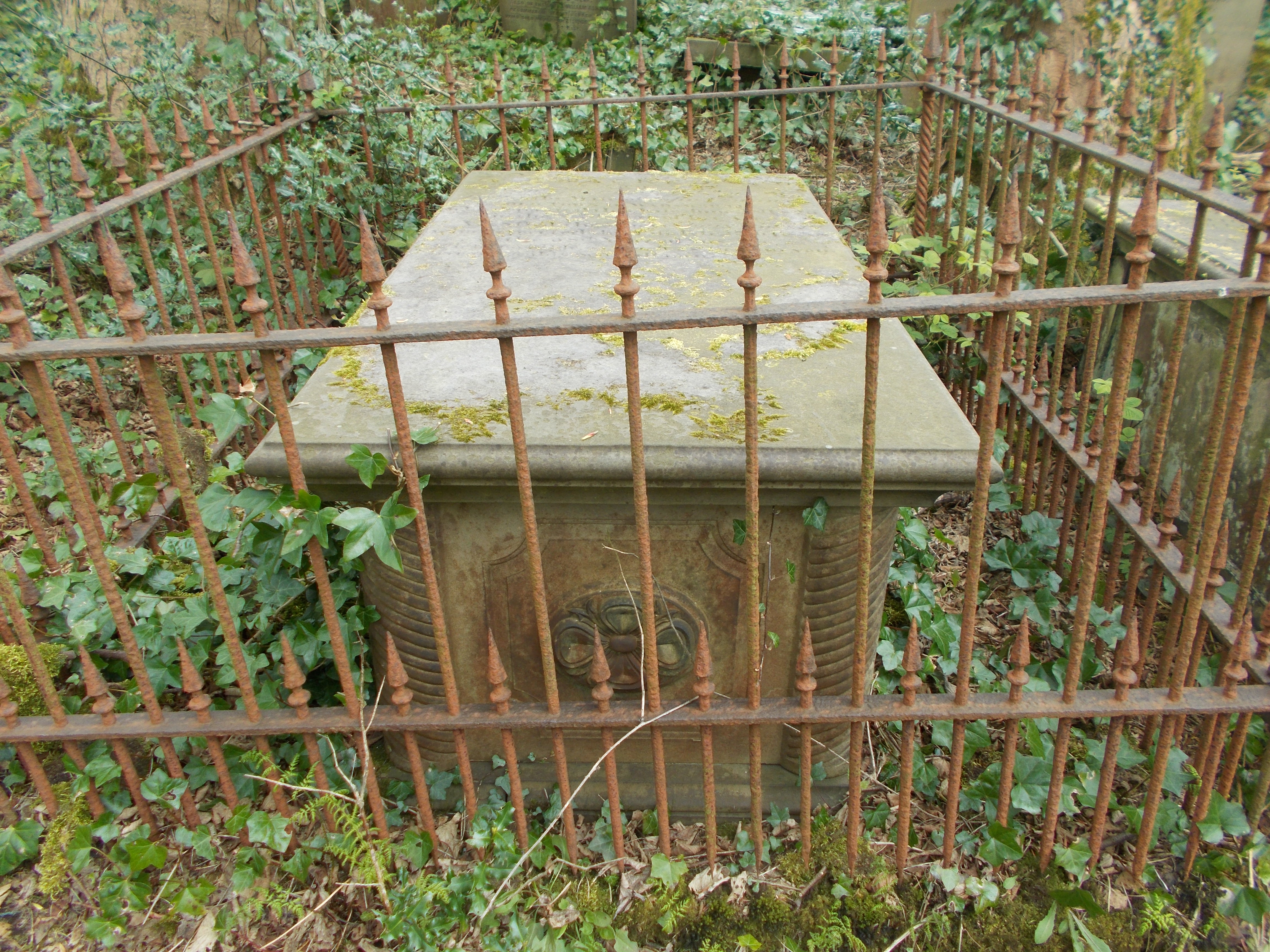
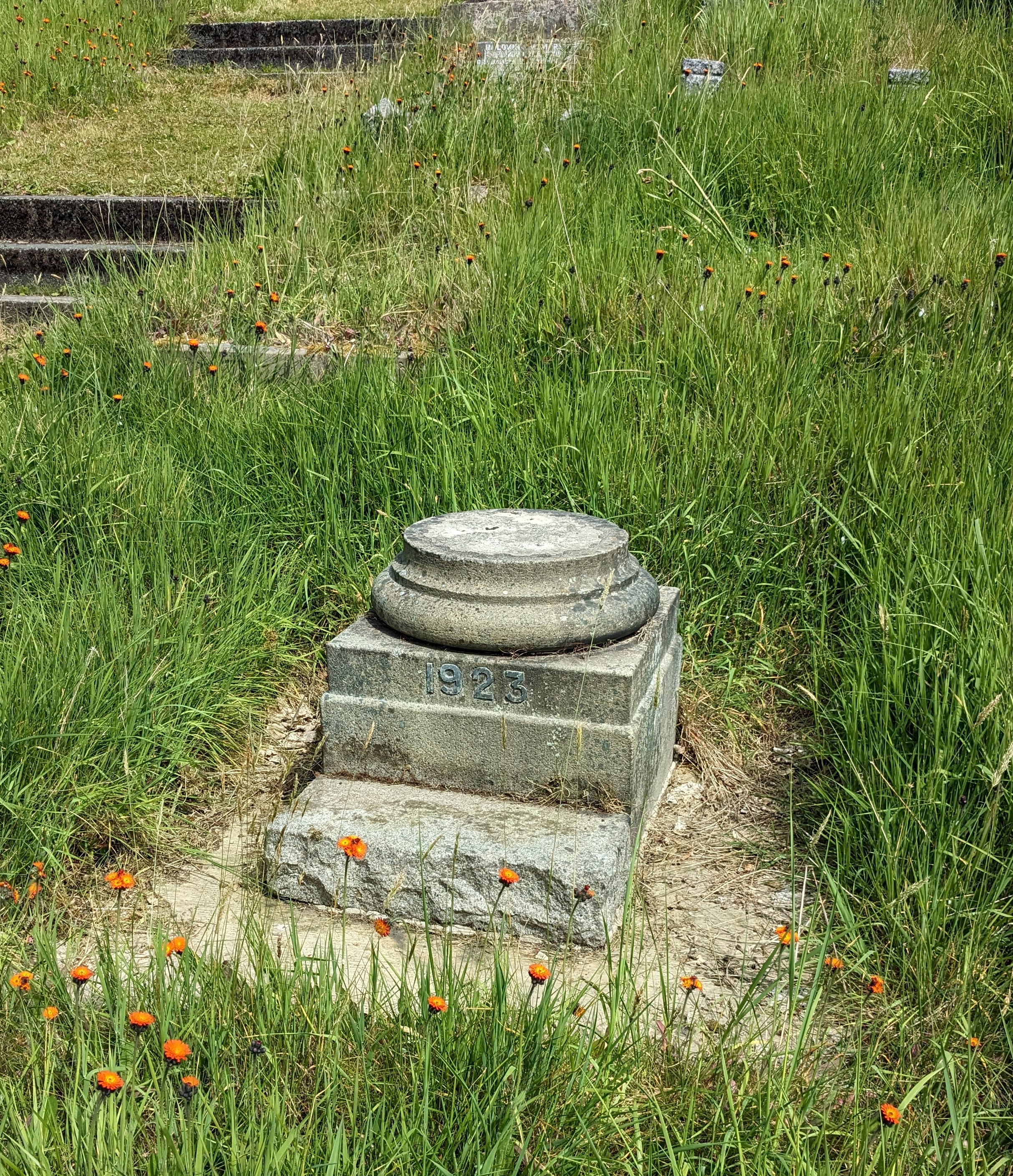
The SUNDIAL
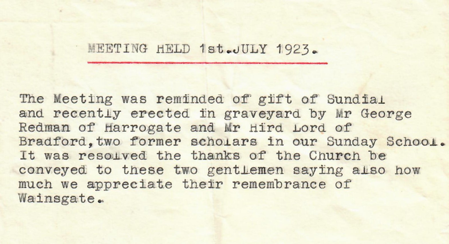
Two adjacent grave plots (E982 & E983), located near the bottom of the stepped path, are believed to have been bought by Clara Mitchell of Boston Hill in 1920. No burials are known to have taken place in these plots, and a sundial was erected in the centre of the space in 1923. Minutes of a meeting dated 1st July 1923 say that the sundial was paid for by George Redman of Harrogate and Hird Lord of Bradford, both of whom were former pupils of Wainsgate Sunday school. Clara Mitchell died on June 9th 1923, aged 64, and the sundial may well have been a memorial to her.
The sundial consisted of a stone base, a column with fluted stone shaft with circular base and capital, a square stone plate and gnomon. The shaft was around 300mm diameter and the height of the column around 800mm. The date 1923 is inscribed on the base in raised lead lettering. The south side of the sundial plate looks as if it was inscribed with the intertwined letters H & L – initials of Hird Lord presumably?
All that now remains of the sundial is the stone base and the circular column base. No one seems to know when the rest of the sundial disappeared or what happened to it. Was it stolen? There are only three known photographs showing the complete sundial, all undated. The photograph above shows the sundial at the far right of the image.
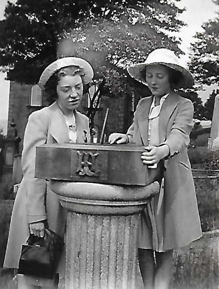
Thanks to Susan Earnshaw for the two undated black and white photographs. The centre photograph shows what remains today.
* * *
The burial ground at Wainsgate is still open for burials, but space is finite: one day it will be full, and there will be no new residents joining this long established community.
The living come with grassy tread
To read the gravestones on the hill;
The graveyard draws the living still,
But never any more the dead.
The verses in it say and say:
‘The ones who living come today
To read the stones and go away
Tomorrow dead will come to stay.’
It would be easy to be clever
And tell the stones: Men hate to die
And have stopped dying now forever.
I think they would believe the lie.
In a Disused Graveyard by Robert Frost (1874-1963)